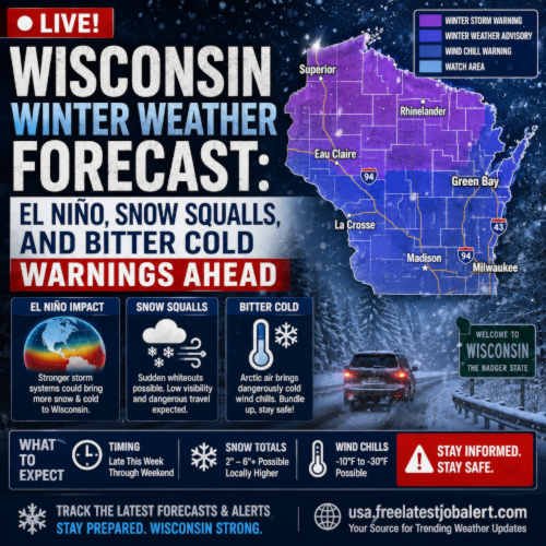
Live! Wisconsin Winter Weather Forecast: El Niño, Snow Squalls, and Bitter Cold Warnings Ahead

What a lovely summer weather it is, and another breaking winter weather forecast with Wisconsin news update. Wisconsin: It’s the latest update we have. While early long-range meteorological models and historical climate indicators point toward an average to potentially milder overall winter season across parts of the United States, meteorologists and long-range forecasters are urging residents not to let down their guard. According to the latest data released by the Old Farmer’s Almanack and regional tracking networks, Wisconsin is bracing for a dramatic season characterised by sharp atmospheric contrasts.
Even with warmer baseline trends influenced by returning global climate cycles, the Upper Midwest faces a high-impact winter featuring sudden snow squalls, blustery winds, and piercing bursts of Arctic air.
What are the factor Shaping the 2026–2027 Winter Engine
The primary driver behind the shifting long-range forecasts is the official return of El Niño. According to updates from the National Oceanic and Atmospheric Administration (NOAA) and the Climate Prediction Center, tropical Pacific ocean temperatures have steadily warmed, establishing an active El Niño pattern heading into the autumn and winter months.
The Pacific Ocean acts as one of Earth’s most powerful weather engines. When its waters warm in key regions, it forces the jet stream—the high-altitude river of air responsible for steering major storm tracks—to alter its course across North America.
However, meteorologists caution against expecting a repeat of the record-breaking warmth seen during the historic El Niño winter of 2023–2024, which brought Milwaukee its warmest winter on record, according to the Wisconsin State Climatology Office. Instead, current projections indicate a more volatile setup where overall seasonal averages mask intense, short-duration weather shocks.
What Wisconsin can expect from this forecast
According to the Old Farmer’s Almanack winter outlook, temperatures across the northern Plains, Upper Midwest, and Great Lakes are anticipated to average near normal overall. Yet, forecasters emphasise that a “near-normal” temperature profile does not translate to a mild or uneventful season.
-
Fast-Moving Clippers: Expect a steady procession of Alberta clippers—rapidly moving low-pressure systems originating from Canada that can drop quick accumulations of powder snow accompanied by sharp drops in temperature.
-
Intense Snow Squalls: Areas across the northern tier of the Midwest and the Great Lakes are at an elevated risk for sudden, blinding snow squalls. These localised bands of heavy snow and wind can reduce visibility to near-zero within minutes, creating severe hazards for interstate travel.
-
Bursts of Bitter Cold: While extended stretches of deep freeze may be tempered by occasional thawing periods, sudden incursions of polar air will drive wind chills down significantly, testing utility grids and heating capacities.
-
The Freeze-Thaw Cycle: Frequent swings between melting and freezing conditions will likely cause hazardous road conditions, refreezing black ice, and variable agricultural field conditions throughout the middle of the country.
Strategies to Prepare for Winter Extremes-Share ideas with neighbours
With unpredictable winter weather patterns on the horizon, state emergency management agencies, transportation departments, and utility providers are already reviewing winter preparedness protocols. Sudden snow squalls and flash freezes are notoriously difficult to predict far in advance, making local weather alerts and real-time radar tracking vital tools for daily commuters.
Homeowners and vehicle owners across Wisconsin are advised to take proactive measures ahead of the deep freeze:
-
Vehicle Winterisation: Checking battery strength, replacing worn wiper blades, testing tyre treads, and stocking emergency car kits (including blankets, flashlights, and non-perishable food).
-
Home Maintenance: Insulating exposed water pipes, cleaning gutters to prevent ice dams, and ensuring heating systems are fully serviced before the first sub-zero snap arrives.
-
Insurance and Legal Preparedness: Reviewing homeowner and commercial property policies to ensure adequate coverage for weather-related structural damages, frozen pipe bursts, or liability related to winter slip-and-fall hazards.
Frequently Asked Questions, FAQs in Short
1. Will the upcoming winter in Wisconsin be as warm as 2023–2024?
Not necessarily. While El Niño is officially active and can elevate baseline temperatures, forecasters predict sharp contrasts this season. Unlike the record-breaking warmth of 2023–2024, the current outlook warns of sudden cold snaps, fast-moving winter storms, and intense snow squalls across the Upper Midwest.
2. What is a snow squall, and why are they dangerous?
A snow squall is a brief, intense burst of heavy snow accompanied by strong, gusty winds. They often arrive suddenly, causing whiteout conditions and plummeting temperatures that frequently lead to major multi-car pileups on high-speed roadways.
3. How does El Niño influence Midwest weather patterns?
El Niño warms the tropical Pacific Ocean, which shifts the position of the jet stream. This shift can redirect storm tracks, influencing where moisture, heavy precipitation, and surges of cold Arctic air travel across the North American continent.
4. Where can I track real-time weather updates and road conditions in Wisconsin?
For continuous updates on developing winter storms, live radar feeds, and emergency travel advisories, check out ongoing reports on usa.freelatestjobalert.com/search or consult official federal tracking data via the National Weather Service.